North Idaho/Northwest Montana 2023-2024 Winter Outlook

Well it is that time of year again, time for the annual winter outlook for North Idaho and Northwest Montana. Many of you have been asking what I anticipate the upcoming winter to look like so here is my best guess based on the research I have conducted over the past several months.
In some ways I anticipate the upcoming winter season for 2023-2024 to be similar to the previous winter but at the same time it also is looking vastly different. Below is the official outlook from NOAA’s Climate Prediction Center for the meteorological winter months of December 2023 through February 2024.
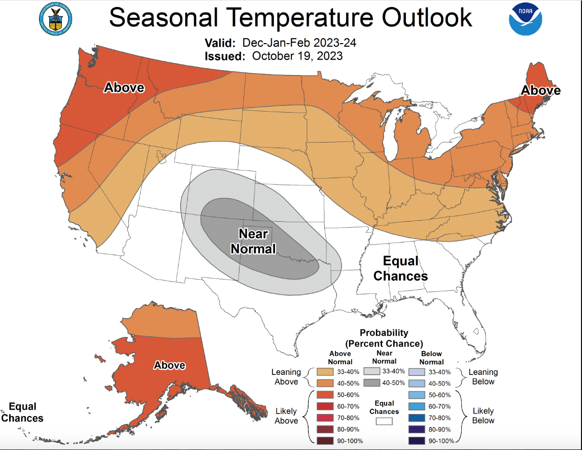
Image Courtesy of NOAA
From this picture we can see that the official forecast from NOAA is showing temperatures for our region in North Idaho and Northwest Montana to be likely above average in the 50-60% probability range and this comes as no surprise. Here is the precipitation outlook for the same time period.

Image courtesy of NOAA
From this picture we can see that NOAA anticipates the winter season to show precipitation leaning below average with about a 40-50% chance of this occurring. In summary then the Climate Prediction Center for NOAA is saying that they anticipate North Idaho and Northwest Montana to have an overall warmer than average winter and a drier than average winter.
Looking back there is only one other winter that correlates well with both teleconnections and ENSO (El Nino Southern Oscillation) data which goes back to 1950. While the status of El Nino or La Nina is NOT the only variable in determining what our winter will look like, it definitely will have some effect. The winter that up to the time of this writing on November 7, 2023 is the winter of 1957-1958. Looking back at the data for that period shows the ENSO indicies almost identical to the most recent ENSO indicies through October across the Pacific. In addition the winter of 1957-1958 followed 3 consecutive moderate to strong La Nina episodes with is identical to this season as we have just come off of 3 consecutive moderate to strong La Ninas. The summer of 1957 was largely dry and warm across all of North Idaho and Northwest Montana as was the summer of 2023 for our region. Finally the autumn of 1957 for September through November was largely wet and mild with the exception of November 1957 in Northwest Montana which ended up being drier but North Idaho was wet. Here is one more chart that I like to look at to make upcoming winter outlooks.

Image courtesy of NOAA
This is a current snow and ice cover chart taken by NOAA November 7, 2023. The white areas are snow cover and yellow is ice cover. This chart is useful as it can often help determine where the Hudson Bay low, or “Polar Vortex” as it is common referenced to now will set up. It is called the Hudson Bay Low due to its semi-permanent location near or over Hudson Bay in Canada. Currently Hudson Bay as of this writing is largely ice-free and the water temperatures in the bay itself are currently running a little warmer than average for early November. Also much of Eastern Canada is now snow covered while much of Western Canada, specifically British Columbia and Alberta are largely snow free outside of the mountainous areas. This is important as the Hudson Bay Low is thermally anchored and sets up over areas that are cold, snow and ice covered. Typically during most El Nino years we see a strong Hudson Bay Low and a corresponding strong Eastern Pacific High or ridge that is often amplified further north along the British Columbia coastline and extends further inland which tends to keep Western Canada drier than average and warmer than average. Here then is my takeaway for the 2023-2024 winter for North Idaho and Northwest Montana.
I am anticipating the winter for our region to likely be near to above average temperature wise and largely agree with NOAA’s prediction with the greater odds of above average temperatures focused across Northwest Montana. As for precipitation, here is where I tend to differ from NOAA’s predictions. I believe our region will likely see near to above average precipitation with the chances of wetter than average conditions being greater across North Idaho and near to perhaps below average precipitation across Northwest Montana. As for snowfall, this looks to be much more elevation dependent this upcoming winter season with elevations above 4,000 to 5,000 feet likely to see above average snowfall but valley locations where people reside likely to see below average to well below average snowfall. Keep in mind that average winter snowfall for valley locations ranges between 60- 90 inches for the entire winter season. With most of our winter weather systems likely to move in from the southwest and largely warm air advection process types of precipitation events, a lot more rain is likely for lower elevations with snow likely to remain much higher up in the mountains. That is not to say we will not see any snowfall but that we will likely see less snowfall than a typical winter. While this may make many people happy to see less snowfall in the valleys the benefits of this are likely to be largely negated as our ground will soon be freezing up and any additional rainfall will not be able to soak into the soil and will simply run-off and go to waste thus creating yet another dry forest if the Spring and Summer of 2024 do not deliver above average rainfall. One other word of caution for the upcoming winter. It is likely that our region will see at least one if not more potentially significant ice storms this winter. While many Northwest Montana valleys typically see a few freezing rain events especially around the Libby area many North Idaho valleys do not and often see a much cleaner transition from snow to rain when it does occur. That may not be the case this winter and I am concerned especially with the large number of new arrivals to our region that freezing rain and the resulting ice storms could end up being a significant problem this winter. The good news for those of you who do not like bitter cold temperatures is that looking back at the winter of 1957-1958 is that no below zero temperatures were recorded at any of the climate stations I was able to look at. Those stations were Priest River, ID, Sandpoint, ID, Rexford, MT, Libby, MT and Thompson Falls, MT. Keep in mind that a lot of what our winter will look like largely depends on where the Hudson Bay Low sets up and the corresponding Eastern Pacific Ridge. Ultimately these two factors will determine our upcoming winter but the overall pattern largely looks to favor a largely mild and wet winter but with the potential of a damaging ice storm at some point this winter.